August to December 1900
Excerpted from USGS Reports
The Gold Belt of the Blue Mountains
of Oregon
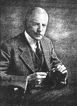
by Waldemar Lindgren
Pocahontas, Auburn, and Minersville Districts
--Placer Deposits--
Nearly every gulch of the south end of Elkhorn Range has been worked on a more or less extensive scale for placer gold, though few localities have been exceedingly rich. Though the bulk of the gold was extracted shortly after the discovery, in 1862, some work is yet going on at several of the old diggings, showing that the gravels are not yet exhausted.
At the northern end of the eastern slope small placers have been worked on Marble Creek, near the limekiln. On Salmon Creek the placers are of much greater importance. This creek was worked with success for about one mile upward from the mouth of the canyon. The gravels were 4 to 10 feet deep and covered by 10 to 15 feet of an exceedingly fine, brilliantly white kaolinic material. The bottom of the canyon was originally filled with deposits to a width of one or two hundred feet. Working downstream, the placer miners at the mouth of the canyon gradually discovered a very remarkable deposit, called the Nelson placers. These have been worked successfully for thirty years by the hydraulic process, and are by no means yet exhausted. The working season extends from April to September, 1,000 miner's inches of water being used. The yearly production has generally been from $20,000 to $30,000. In the mint reports for 1889 the production is given as $77,000; in 1890, $19,000. The total production is believed to be over $400,000. For one period of six years the production is said to have reached $214,000. As the available grade is small, it is proposed to use a hydraulic elevator for mining below the level of the permanment sluice.
The mouth of Salmon Creek Canyon is marked by a low spreading debris fan. The Nelson placers are working the gravels of this fan in a pit covering 40 to 50 acres and from 20 to 100 feet deep. At the top of the bank the elevation is 3,750 feet. The gravel is subangular, many fragments reaching 1 foot in diameter, and consists of argillite and diorite, very little quartz being present. There are two layers,. The upper stratum has a bluish-gray color, is 10 to20 feet thick, and contains, evenly distributed, most of the gold, The lower stratum is yellowish-brown and its rocks are more decomposed. This also contains gold, though in lesser amount, and its bottom has never been reached. Covering the top layer, near the mouth of the conyon, is the same white kaolin which covers the gravels of the creek. The gold, which is worth only $14 to $16 per ounce, is ordinarily fine, though nuggets up to $10 in value occur. To the rough pieces quartz sometimes adheres.
Most interesting are the relations immediately at the mouth of the canyon, for here the hydraulic work has disclosed the presence of a continuous fault scarp 100 feet high and dipping 40' E. It is smooth now, but when first exposed it is said to have been almost polished and in places covered with a clayey gouge, The direction is northwesterly, but with occasional bends and bulges. The exposed fault line extends completely across Salmon Creek for a distance of 1,500 feet, and the same line, less well exposed, is seen in the Baisley diggings, one-fourth of a mile northward, and in the Carpenter placers, half a mile south-easterly.
A shaft has been sunk in the bottom of the hydraulic pit near the foot of the scarp, but no bed rock was found to a depth of 90 feet. A minimum vertical throw of 200 feet is here, the valleyhaving sunk relatively to the mountains. The upper blue gravel probaly was accumulated during the Glacial epoch, while the lower dark-brown gravel is more likely to antedate that time; whether any recent movement has taken place could not be decided.
Small placers have been worked in Washington Gulch, and the same applies to Griffin Creek and Elk Creek. The Griffin Creek placers are the oldest in eastern Oregon, having been discovered in the fall of 1861. The workings are 6 miles southwest of Baker City and at an elevation of 4,750 feet above where the creek enters the lava hills. Some work was in progress in 1900. On the divide between Griffin and Washington creeks is a small area of high gravels which is said to contain gold in paying amount.
Most important were the placers of Auburn in Blue Canyon, a tributary of Powder River, the diggings were discovered in 1862, and in a short time a town of several thousand inhabitants had grown up. For many years Auburn was the most prominent place in eastern Oregon: but the gold yield gradually diminished and the camp was given over to the Chinese. At the present time hydraulic mining is carried on by two or three white companies. The total production of Auburn is difficult to determine, but it did not nearly reach that of Canyon and the riches placers were soon exhausted. A small and rather steady production is maintained. The Mint reports give $12,000 for 1889, $2,600 for 1890, $8,900 for 1891, $3,000 for 1892. The important Auburn ditch was completed in 1863. It takes water from the head of Pine Creek and other water sources and carries it down to Auburn. A distance of over 30 miles; its capacity is 1,000 miners' inches.
Auburn is located in a wide basin-like valley at an elevation of about 4,000 feet. The argillites of the mountains here dip below the lava floods of the foot hills. On both sides of the town the lava reaches up to the elevation of 4,500 feet. The lavas cover soft, clayey, and loamy lake beds containing some coaly layers and impressions of disciduous leaves. On top of the eroded lake beds in the wide gulch rest sub-anglular gravels eight to 15 feet thick: the lava having been washed both in the gulches and on the flats. Near the town the depth to bed rock is not great; but further down the valley the thickness of the sediments increase rapidly. The gravels are thus later than the lavas and have accumulated during the erosion of the present valley.
West of Auburn, on the road to Sumpter, several gulches with old placers are passed. Poker Gulch and California Gulch being next to Blue Canyon.
The deposits next in importance are found at Minersville, situated at an elevation of 4,300 feet on one of the small tributaries of Deer Creek. This is also an old placer camp, though not as rich as Auburn. Nearly all of the creeks following into Deer Creek from the east have yielded more or less placer gold. Miners Creek is worked at present on a small scale at the point where the stream leaves the old rock and enters the gravel deposits of Sumpter Valley. The gravel is coarse with many heavy bowlders, and the gold is likewise coarse. Three short gulches southeast of Minersville, heading only 600 feet higher than the town, have been worked all the way up and the gold contained in them is evidently of very local origin, in spite of this the gulches contained but little quartz.
These stories are available to our electronic readers as part of our contribution to the information available on the Internet. We're interested in hearing from you especially if you've been to Eastern Oregon, the Wallowas, the Blues, or if you know of Prof. Lindgren and his trips to the many other gold camps in the West. These stories are available to our electronic readers as part of our contribution to the information available on the Internet. We hope you enjoy the stories and if you have questions or comments please send a message to editor, Keith Whittle
More on Waldemar Lindgren:
[Editor's Introduction | "Gold Belt of Eastern Oregon"]Read our other gold mining editions:
[Sumpter, Oregon 1900 | Gold Seekers Rush to California]
[ Oregon: Land of Gold & Opportunity | Dequille Reports from the Comstock]

Bridget E. Smith, editor & publisher
Email | Home Page | Historic Headlines
Historical Gazette
Published in Portland, Oregon
© 1991-